Antarctic map for free download: Bring Antarctica into your home
Hello,
I have a question for you:
Have you ever noticed that Antarctica is not shown on some world maps? It's as if it doesn't exist; in the southernmost region, you will find only masses of water, but no seventh continent. Very rarely will you find even a white spot.
Is it just me, with my special affinity and love for Antarctica, who notices this, or have you observed it too?
Now that I've asked you this specific question, you will most likely pay more attention in the future to whether Antarctica is at least depicted in realistic outlines.
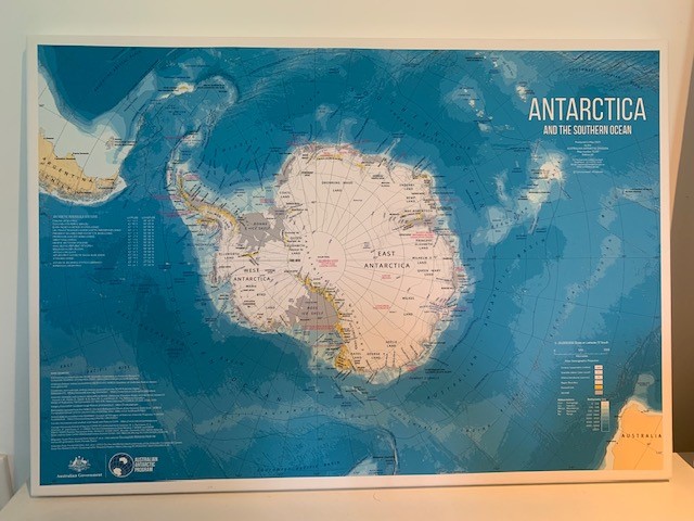
I was all the more delighted when I came across this great map some time ago, which I would like to give you as a gift.
That sounds more generous than it really is, because the gift does not actually come from me, but from the Australian Antarctic Division (AAD), the Antarctic division of the Australian government.
On a scale of 1:20,000,000, the map shows detailed topography, bathymetry, research stations with their corresponding names, average ice extent, and much more information.
And just to give you a more realistic idea: Germany would fit into Antarctica about 37 times, and the Antarctic Peninsula (the tip that juts out toward South America) is about 1,000 km long.
Would you like to travel to Antarctica?
Get answers to the 10 most frequently asked questions about the fascinating travel destination of Antarctica.
What I particularly like is that not only is Antarctica depicted in great detail, but so are all the routes as well as all the starting and ending points of our entire Antarctica portfolio:
- Ushuaia, the southernmost city in the world on the Argentine part of Tierra del Fuego, is the starting point for most of our Antarctic voyages.
- Punta Arenas, in southern Chile's Patagonia region, where our Antarctic voyages begin with a flight across the Drake Passage ("Skip the Drake").
- The Falkland Islands in the South Atlantic, the "very British" animal paradise
- South Georgia, the Serengeti of Antarctica
- The South Sandwich Islands
- The South Orkney Islands, where only a handful of people land each year
- King George Island in the South Shetland Islands: This is where you land when you fly from Punta Arenas to Antarctica.
- The Weddell Sea on the eastern side of the Antarctic Peninsula
- The Antarctic Peninsula, the most visited region in Antarctica—unfortunately not shown in great detail, which is, of course, due to the size of the map
- The Ross Sea, the world's largest marine protected area since 2017
The map was created using a geographic information system (GIS), which offers many new possibilities compared to a photography or graphics package.
This allows data sets from various sources to be combined, such as satellite images and reference models for topography and many more.
I had the map printed in DIN A2 format on canvas, and now it adorns my office next to the large world map (see above).
Download the Antarctic map here.
The AAD has given permission. Please be patient, it takes a little while for it to load completely.
Where will you hang your map? Send me a photo of it!
Have a safe trip!
Yours, Stephanie Gräf
All Antarctic trips at a glance
We have clearly presented all our trips with dates and prices for you.
Shall we stay in touch?

Stephanie Gräf
Owner & Founder
Since 2002, I have been personally advising clients on unique expeditions and private trips, small-ship cruises, and journeys to remote regions of the world.
We'd be happy to discuss your trip with you in person.
Why not contact me right now at Phone: +49 201 85890960 or email welcome@inventia.de.
Or schedule a free, no-obligation one-on-one phone call (also via WhatsApp or Wi-Fi), a Teams or Zoom meeting here—even in the evenings or on weekends:

Are you interested in Antarctica but don't know where to start?
Our FREE Antarctic Mini-Guide sheds light on the ice.
Are you interested in Antarctica but don't know where to start?
Our FREE Antarctic Mini-Guide sheds light on the ice.
Newsletter: Travel beyond the ordinary
Stay in touch with us and receive our latest travel ideas on a regular basis.